Virginia Outdoors Foundation Protected 39,000 Acres of Open Space in 2011

The Virginia Outdoors Foundation permanently protected 39,000 acres of open space through 215 conservation easements in 2011, or roughly four acres every hour. That is a 50-percent increase from 2010.

VOF recorded easements in 66 localities, including its first easement in Mecklenburg County — a 121-acre farm that has been in the same family for more than a century.

Bath County had the most open space protected with 2,655 acres on eight easements.

VOF now protects about 650,000 acres across 106 localities — an area half the size of Delaware. Of the nearly 800,000 acres of open space protected in Virginia since 2000 by all federal, state, local, and private entities, approximately two-thirds have been protected by VOF easements.

To see how much open space VOF protects in each locality, visit vof.org/stats.

Conservation easements are voluntary agreements between private landowners and a qualified land trust such as VOF that restrict future development while allowing compatible uses such as farming, forestry, and recreation. Because of the public benefits of protecting open space, habitat, water quality, and other conservation values, landowners who donate easements can receive state and federal tax incentives.

In its recent “Review of the Effectiveness of Virginia Tax Preferences” at http://jlarc.virginia.gov/reports.html, Virginia’s Joint Legislative Audit & Review Commission deemed the commonwealth’s Land Preservation Tax Credit Program to be one of the most effective and cost-efficient of all state tax incentive programs.

VOF was established by the Virginia General Assembly in 1966 to encourage the preservation of the commonwealth’s natural and cultural heritage lands. It operates seven regional offices in Virginia and holds more conservation easements than any land trust in the nation.

New Report Shows VA Leading Southeast in Voluntary Land Conservation

A new report from the Washington, D.C.-based Land Trust Alliance reveals that land trusts in Virginia conserved more land between 2005 and 2010 than any other state in the Southeast.

The 2010 National Land Trust Census includes statistics from private nonprofit land trusts, as well as the Virginia Outdoors Foundation, a public land trust created by the legislature in 1966.

According to the Virginia Department of Conservation and Recreation, which tracks all land conservation activity in the commonwealth, 314,225 acres were conserved by VOF and 78,678 acres were conserved by private land trusts between 2005 and 2010. That works out to about seven acres preserved every hour.

The Land Trust Alliance census reports that the next-closest Southeastern state was North Carolina, where land trusts conserved about 132,000 new acres during the same period.

The primary tool for land trusts is conservation easements, which are voluntary agreements between landowners and nonprofit or governmental entities that restrict intensive development on open space while allowing landowners to continue to own, enjoy, farm, timber, and sell the property or pass it on to heirs.

Because easements protect public benefits such as water quality, wildlife habitat, and scenic open space, Virginians who donate easements are eligible for federal and state tax benefits, including tax credits through Virginia’s Land Preservation Tax Credit Program.

Earlier this week, at a presentation of a forthcoming report analyzing the effectiveness and efficiency of Virginia’s major tax preference programs, the Joint Legislative Audit and Review Commission cited the Land Preservation and Historic Rehabilitation tax credit programs as the two most effective and cost-efficient programs among those that were evaluated.

VOF assists Northampton County with 172-acre PDR easement

From Pete Henderson, Northampton County PDR Committee chair 

Northampton County protected a second working farm last week through its Purchase of Development Rights (PDR) Program, with the acquisition of a conservation easement on Nottingham Farm near Franktown. Cousins Butch and Add Nottingham of Nassawadox agreed to permanently restrict land use on their 172-acre property in a deal that combined both the sale and donation of development rights to the county and the Virginia Outdoors Foundation.

The Nottinghams’ conservation easement permits traditional land uses — like farming, forestry, hunting and fishing — but prohibits subdivision or lot sales. “I am very happy,” said Add Nottingham. “This farm would have ended up covered in houses sometime in the future and I am glad it will remain a working farm.”

Nottingham Farm qualified for the county’s PDR program due to its outstanding natural resources and proximity to other protected lands. The farm contains 145 acres of prime agricultural soils, nearly 16 acres of forest and 1,800 feet of buffer on a perennial stream, which supports wildlife and migratory bird habitat. The farm is close to two others protected by conservation easements, 240-acre Happy Union and 157-acre Locust Grove, for a total of 569 acres protected between Franktown and Wardtown.

Northampton County contributed approximately 11 percent of the total value toward the acquisition of the Nottinghams’ development rights, half of which will be reimbursed to the county by the Virginia Department of Agriculture and Consumer Services Office of Farmland Preservation. The county dedicates one percent of its annual Transient Occupancy Tax (TOT) revenue, paid by visitors to local hotels, motels and campgrounds, to the PDR Program to preserve the working lands that are such a distinctive feature of the Eastern Shore.

The Nottinghams donated 25 percent of the easement value, while the remaining 64 percent was covered by a complicated array of state and federal grants. Peter Stith, the PDR Program Administrator in the county’s Department of Planning and Zoning, coordinated the easement acquisition with guidance from the Board of Supervisors and an appointed committee of farmers, conservationists and public servants.

“The purchase of a conservation easement with multiple funding sources can make for an extremely complex and challenging real estate transaction,” said PDR Committee member Dave Harris of the Nature Conservancy. “Peter Stith did a great job meeting the requirements of the four funding agencies and coordinating all of the paperwork necessary to bring this transaction to closure.”

The Northampton County PDR program is voluntary, but landowners must meet certain criteria to be eligible for consideration. At least 50 percent of the tract must contain prime agricultural soils based on the most recent maps in the county’s Planning and Zoning Department. The property must be located in either an A-1 Agriculture or Conservation zoning district or the Agriculture/Forest Land Use Area, as mapped on the Future Land Use and Development Map in the County’s Comprehensive Plan. The easement serves as a permanent deed restriction that limits future development and requires the landowners to implement forest management plans and best management practices for farming.

Maintaining productive farm and forest land can yield Northampton County tremendous savings by offsetting the cost of providing public services, like roads or utilities, to rural areas. A recent Cost of Community Services study by the American Farmland Trust indicates that for every $1 collected in real estate taxes, $1.19 is spent on services for residential development compared to just $0.37 required in services for open working land.

“The Northampton County PDR Program continues to illustrate how small investments in protecting our rural assets save county taxpayers a lot of money over time,” said Peter N. Henderson, the PDR committee chairman. “Completing a second purchase demonstrates that Northampton residents and county supervisors continue to support the preservation of the county’s rural nature and farming.”

VOF Protects 600,000th Acre; Adds 25,185 Acres in 2010

A century-old family farm in southern Pittsylvania County has become home to the 600,000th acre protected by the Virginia Outdoors Foundation (VOF), Virginia’s largest land conservation organization, VOF Executive Director Bob Lee announced today.

Hill View Farm’s owners, Bob and Billie Pollok, finalized the donation of a 252-acre conservation easement on the property to VOF last week. Conservation easements are voluntary agreements between landowners and qualified land trusts that protect open space from extensive commercial and residential development while allowing compatible uses such as farming, forestry, and recreation.

The easement is one of 126 easements VOF recorded overall in 2010, protecting 25,185 acres across 51 counties and independent cities. Nearly 75 percent of the easements protect agricultural land. The easements contribute to Governor Bob McDonnell’s goal of protecting 400,000 acres of open space during his administration.

“I want to congratulate the Virginia Outdoors Foundation for achieving such an impressive milestone,” said Governor McDonnell. “Conserving Virginia’s spectacular landscapes is one of my top priorities. Bob Lee and the VOF are leaders in this effort.”

Hill View Farm has been in the Pollok family since 1884. For the last 25 years, the Polloks have been operating primarily as a certified seed grower — producing and selling wheat, barley, oat, and soybean seeds to other farmers in Virginia, North Carolina, and Maryland. They practice no-till farming to reduce soil erosion, have set aside portions of the property for wildlife habitat, and have fenced livestock out of springs and streams. Their stewardship efforts have earned them Clean Water Farm and Cooperator of the Year awards from their local soil and water conservation district.

“We saw housing developments going up all around us and seed farms being cut up completely, and we just didn’t want that to happen to our farm that has been in operation for generations,” said Mr. Pollok. “With the easement, we are doing the best we can to preserve it as a working farm.”

Because of the public benefits of protecting open space, habitat, water quality, and other conservation values, landowners who donate easements in Virginia can receive state and federal tax benefits.

VOF now holds more than 3,100 easements covering 606,534 acres across 105 localities. That is more conservation easements than are held by any other land trust in the nation. VOF protects more land than any other state, local, or private entity in Virginia.

VOF, NRCS Partner to Protect Family Dairy in Rockbridge County

By Barbara Bowen, NRCS

“When milk prices tanked, nobody saw it coming. Instead of using the money to better the farm, we are now using it to buy the farm.”

That simple statement from Rockbridge County dairy owner Linda Leech summarizes the positive impact conservation easements can have on farm families. Offered through a partnership between the Natural Resources Conservation Service (NRCS) and the Virginia Outdoors Foundation (VOF), this practice offers dual benefits as producers receive financial compensation to keep their agricultural land in the family and protect it from development.

Linda and her husband, Charles, are continuing a farming legacy that stretches back generations. Along with their children, Beau and Jennifer, the Leeches proudly own and operate Ingleside Land LLC in an idyllic mountain setting just outside the City of Lexington.

Farming in the area has diminished from about 28 dairies in Charles’ grandfather’s time to about seven today. VOF easement manager Laura Thurman says much of the available land is being sold at higher than appraised value for housing subdivisions, and it is difficult for individuals who don’t own the land to begin farming. Those who return to the area find the land prices in Rockbridge County prohibitive for agricultural production.

The Leeches are full-time producers who earn no significant income outside of the farm. The family previously rented pasture and crop land from David Tardy’s Buffalo Farms for their growing dairy herd, which now numbers at just over 300 cows and about 310 replacement heifers. At that time, they simply did not have enough acreage to raise the amount of feed needed for their herd or to provide adequate pastureland for them.

Ingleside Dairy Farm, Inc., encompassed about 650 acres when the Leeches purchased 168 acres from Buffalo Farms in July 2007. (About 95 acres of the new purchase are currently in crops, and the remainder is used as pastureland.) The Tardy’s are long-time family friends and Charles knew of David Tardy’s desire that his land remain in agricultural production.

“If we had been the type of people to buy a farm and see how many bucks we could get from it, we would’ve never gotten this land,” says Charles. “If we had been that type of people, we would have never known it was for sale,” adds Beau.

Thurman says the Leeches bought the land when real estate was going for a higher price and reached out to her about protecting the land when the “bottom fell out.” “Farmers are very adept at cost benefit analysis, and this purchase makes more sense for them,” she adds.

Thurman worked with NRCS to enroll the Leeches in the Farm and Ranch Lands Protection Program (FRPP) to protect just over 166 acres from development and to help the family keep their farm. She says the easement proposal came together quickly, with funding approval coming through the VOF board in 2009. To purchase the development rights, NRCS provided 50 percent of the funding through FRPP, VOF provided 25 percent through its Preservation Trust Fund, and the remaining 25 percent was donated by the family to the Commonwealth, for which they will receive state and federal tax benefits.

VOF, which holds more than 3,000 easements across 600,000 acres of land, will be responsible for stewardship of the property as this highly productive farmland goes into perpetual easement (more than 80 percent of the soils are prime or of statewide importance). Historic dwellings dating back to the 1800s are also located on the easement land, which fronts a native trout stream on Buffalo Creek.

All four members of the Leech family hold B.S. degrees in dairy science from Virginia Tech and made a joint decision to protect their land and way of life. NRCS FRPP Manager Barry Harris says that getting the children involved in the easement decision has helped to ensure the farm’s viability for years to come. Beau summarizes their family’s commitment to the dairy business in the simple statement, “That’s what we do.”

Charles and Linda say they created the LLC to give their children a vested interest in the business. Beau and Jennifer, who each own a 25 percent share of Ingleside Land LLC, are already dividing and conquering the business of helping to run the dairy and managing the three full-time and two part-time employees. Jennifer does the books (both financial and herd) and much of the milking and heifer care, while Beau focuses more on crop work, feeding, and equipment.

Harris adds that operations stay afloat these days by “not doing things the same way” and benefiting from available technical advice on conservation practices, such as no till and nutrient management. NRCS Lexington District Conservationist Charlie Ivins adds that the Leech children are in a unique position because their father is using cutting edge technology on the farm. Thurman echoes that sentiment, stating that Ingleside is “one of the cleanest, neatest dairies I’ve ever seen and employs a number of best management practices.”

The Leeches don’t see a strong down side to conservation easements and would recommend the practice to other farmers. Charles says the construction restrictions on the site wouldn’t really affect them because “we have enough buildings on the property already. If something happened to one of our buildings, we could just put up another one in its place.”

“You have to think about future generations,” says Linda. “Will they be glad the easement is in place? If so, why not get some monetary benefit from it?”

This article originally appeared in the July 2010 issue of Current Developments, published by Virginia NRCS.
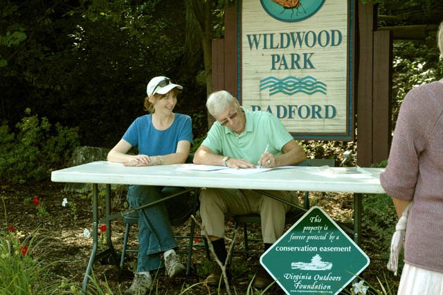
City of Radford, VOF Partner to Protect Wildwood Park

Over the centuries, Wildwood Park in downtown Radford has been a Native American burial ground, a saltpeter mine, the site of a Civil War battle, and the city’s first park. Today, it contains a city greenway for recreation and nature study, with biking and hiking trails, marshes, meadows, limestone cliffs, and numerous rare species.

Now, thanks to a conservation easement donated by the City of Radford to the Virginia Outdoors Foundation (VOF), Wildwood Park will remain a protected area for future generations of nature lovers.

The easement, which was proposed by Radford Mayor Tom Starnes in 2008, was finalized by VOF and the city this week. As the easement holder, VOF, which was created by the Virginia legislature in 1966 to preserve open space, will ensure that the 54 acres under easement can never be divided, developed, or opened to commercial timbering. The easement places strict limits on the number of buildings and parking areas that can be added in the future, and prohibits any kind of development within 50 feet of Connelly’s Run, which flows through the property and into the New River.

“I frequently visit Wildwood Park and always return with a tranquil feeling and a deeper appreciation of nature,” said Mayor Starnes. “The conservation easement will assure current and future residents of the City of Radford that development will not occur in this protected area.”

Wildwood Park is a unique natural resource for the city. The park contains several natural heritage resources including two rare plants, a rare butterfly, a significant natural community and a state-designated significant cave called Adams Cave. The Riverway, a popular three-mile paved pedestrian trail, bisects the park, and several foot paths break off into the woods for bird-watching and wildflower walks. The park is a component of the Virginia Birding and Wildlife Trail and is often used by both Radford City and Radford University students for outdoor nature studies.

The park is also rich with history. According to the Radford Historical Society, Native Americans used Adams Cave as a burial ground until about the 1600s. The cave was later mined for saltpeter, a key component of gunpowder, during the War of 1812. During the Civil War, the area was the site of the three-hour Battle of Central, which resulted in cannonball damage to “Arnheim,” the historic home of John Blair Radford, which is adjacent to the park and is listed on the National Register of Historic Places.

In 1929, a swimming pool was built along Connelly’s Run and the area became the first city park. The following year a competition was held to find a name for the new park. Alleen Carper, a student from Radford’s State Teachers College, had the winning entry with “Wildwood.” Eventually, the pool was closed and filled with dirt. The park continued to be used for hiking and other outdoor recreation and education activities but was mostly neglected. In 1998, a group of local citizens formed Pathways for Radford to preserve and revitalize the park and help create and maintain a network of walking and biking trails and greenways throughout the city.

Liz Altieri, president of Pathways for Radford, said, “It’s been a pleasure to be a partner with the City of Radford in ensuring permanent protection of Wildwood Park through the VOF conservation easement. Our organization was formed more than 12 years ago from this very concern, that this model urban riparian forest be preserved forever.”

Ruth Babylon, an easement specialist with VOF who worked on the project, said, “I have a soft spot in my heart for this easement. I lived in Radford for almost 20 years and was an original member of Pathways for Radford. I’ve been associated with a lot of great easements in my ten years with VOF, and this one is truly a gem.”

The Wildwood Park easement is VOF’s second easement within the City of Radford. The other protects 149 acres on Ingles Farm along the New River, which was donated in 2002 by the farm’s owners, Bud and Mary Ann Jeffries. Last year, the rest of the historic Ingles property, on the Pulaski County side of the river, was placed under an easement co-held by VOF and the Department of Historic Resources. Altogether, VOF protects about 12,000 acres in Radford and adjacent Pulaski and Montgomery counties.

Botetourt County Birding Hot Spot Protected by Easement

One of the most popular places for bird-watching in Botetourt County has been permanently protected from development, thanks to a conservation easement donated by the property’s owner to the Virginia Outdoors Foundation.

The 106-acre tract, owned by Barry Kinzie, is located along Stoney Battery Road just outside Troutville. The land has been in his family since before the Civil War, supporting the family’s farming and orchard business. Kinzie, who is 65 and retired, lives there with his wife, Teresa.

In the 1990s, Kinzie and his friends from the Roanoke Valley Bird Club began improving bird habitat and blazing trails throughout the property. They eventually added feeding stations, butterfly gardens, parking areas, and a hawk-watching platform. For his efforts, Kinzie has received conservation awards from the Virginia Society of Ornithology and the Daughters of the American Revolution. Today, Woodpecker Ridge is open to the public free of charge and featured on the Virginia Birding and Wildlife Trail, attracting about 1,000 visitors annually.

Explaining why he protected the land with an easement, Kinzie said, “I have respect for what my father and grandfather did to keep this farm. I want to keep it in undeveloped condition for many in the future to use, view, enjoy, and learn from.”

Kinzie was encouraged to do the easement by Genevieve Goss, a longtime volunteer at Woodpecker Ridge and the Botetourt conservation steward for Valley Conservation Council, a nonprofit land trust. After keeping Kinzie updated over the years on conservation easements and other voluntary tools for land conservation, Goss was delighted when he was able to move forward with the easement.

“Since Woodpecker Ridge is such a treasured spot both for the Kinzie family and the nature lovers of the area, it was my privilege to work with Barry to protect the land permanently,” she said.

The easement protects the property’s natural resources by restricting future development. The land can never be divided, there are limits on the number and size of new structures, and there is a special no-build area that protects scenic views of the property from the Appalachian Trail as well as a public drinking water supply at the base of the ridge. The easement allows for managed expansion of facilities related to public use of the property, such as trail markers, benches, and a public restroom.

“This part of Botetourt is experiencing a great deal of large-lot development pressure, and Mr. Kinzie could have easily sold the property for housing,” said VOF’s Laura Thurman, who managed the project. “Instead, he has shown tremendous generosity by not only opening his land to the public for bird-watching, but also by donating an easement that ensures the land will remain open for generations to come.”

VOF now manages 39 easements in Botetourt County, protecting close to 15,000 acres. Statewide, VOF protects about 600,000 acres — three times more land than in Shenandoah National Park.

Since 2000, VOF has preserved open space in Virginia at a rate of about five acres every hour.

VOF Records Its First Easement in Isle of Wight County

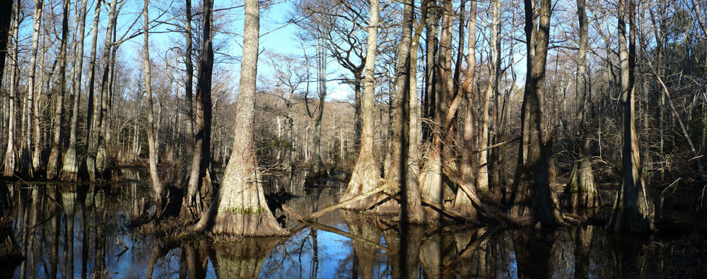
The Virginia Outdoors Foundation (VOF) has helped to preserve a wildlife-rich cypress swamp in Isle of Wight County, thanks to a conservation easement recorded late last week. It is the first easement in Isle of Wight County for VOF, which now protects land in all but four Virginia counties.

The 38-acre easement protects a section of Great Swamp known as the Millpond tract, which is owned by the county. At one time the swamp had been dammed, forming Courthouse Millpond, named for its proximity to the county courthouse. The dam eventually blew out and drained the pond, leaving behind a mature cypress swamp. The swamp flows into Burnt Mills Reservoir, which supplies drinking water to the City of Norfolk and drains into the Nansemond River.

The Virginia Department of Game and Inland Fisheries has surveyed the property and found it to be rich with amphibians, reptiles, fish, and birds — many of them identified as “Species of Greatest Conservation Concern.”

The easement includes development restrictions that will help to keep the water clean and the habitat intact.

Phillip A. Bradshaw, Chairman of the Isle of Wight County Board of Supervisors, states “This property outlines our courthouse complex and it provides an excellent opportunity for us to take another step forward in protecting and preserving our environment for future generations. We hope that we will be able to offer opportunities in the near future for the public to enjoy this natural amenity, perhaps with a walking trail and a gazebo.”

“The public benefits of this easement — clean drinking water, pristine habitat, recreational and educational opportunities — are tremendous,” said VOF Chairman Hank Hartz of Goochland. “It’s a great example of how local governments can protect those values that define their community’s quality of life.”

VOF Protected 55,000 Acres in 2009

The Virginia Outdoors Foundation permanently protected 55,000 acres across 61 localities through conservation easements in 2009, making it the fourth straight year that VOF protected more than 50,000 acres.

“VOF now protects 580,000 acres across 102 cities and counties—an area three times the size of Shenandoah National Park,” said VOF Board Chairman Hank Hartz, a resident of Goochland. “About 285,000 of those acres were recorded within the past five years—many on working farms and forests.”

For the second consecutive year, Amelia County led all counties in VOF protected land with 5,280 acres. Also in 2009, VOF completed its largest project ever—more than 11,000 acres of Carvins Cove Natural Reserve in Roanoke. Other highlights included 5,000 acres placed under easement on Smith Mountain spanning Pittsylvania and Bedford counties, 1,271 acres that protect the drinking water supply of Purcellville in Loudoun County, and about 1,000 acres on two of the state’s historically significant properties, James Madison’s Montpelier in Orange County and Ingles Ferry Farm in Pulaski County.

State’s Largest Easement Completed on Carvins Cove

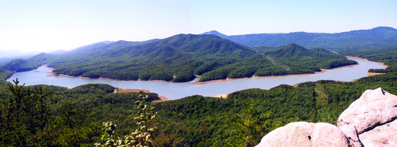
The City of Roanoke has completed the donation of a two-part conservation easement in Roanoke and Botetourt counties that permanently protects 11,363 acres of open space, making it the largest easement in the state. The first part, comprising 6,185 acres, was placed under easement in 2008; the remaining 5,178 acres were placed under easement last week.

The easement, co-held by the Virginia Outdoors Foundation (VOF) and the Western Virginia Land Trust, is on the Carvins Cove Natural Reserve, the second-largest municipal park in the nation. The property is owned by the City of Roanoke and surrounds Carvins Cove Reservoir, the largest source of public drinking water for several municipalities in the Roanoke Valley, including the City of Roanoke, Roanoke County, and the Town of Vinton. The Western Virginia Water Authority owns the reservoir and water treatment plant, not included in the easement.

“The latest easement is the culmination of a decade and a half of efforts by the local land preservation leaders, state agencies, and local elected officials,” Governor Timothy M. Kaine said. “It exemplifies the spirit of partnership that makes Virginia’s land conservation program so successful, and is a testament to the foresight of Roanoke’s citizens to protect this critical resource for generations to come.”

The Carvins Cove Natural Reserve is managed for watershed protection and public recreation, including hiking, fishing, boating, and equestrian use. The property is located near Interstate 81 and borders 14 miles of the Appalachian National Scenic Trail. The rock outcrop at nearby McAfee’s Knob, which overlooks the conserved property, is one of the most frequently visited and photographed panoramas on the Appalachian Trail. The Virginia Department of Conservation and Recreation’s Division of Natural Heritage has identified rare biological communities on the property, which the easement will protect by limiting future development.

“From wildlife habitat to public recreation to drinking water for thousands of citizens, no VOF easement protects as many public values as these 11,000 forested acres,” said Roanoke resident and VOF trustee, Dr. M. Rupert Cutler, who also is a member of Roanoke City Council.

VOF now protects more than 20,000 acres in Botetourt and Roanoke counties, and nearly 550,000 acres of natural, scenic, historic, open-space, and recreational lands statewide, including more than 4,000 miles of streams and 200,000 acres of farmland. The Western Virginia Land Trust, a private non-profit land conservancy, has helped to preserve more than 76,000 acres of land and 30 miles of streams in southwest Virginia since 1996.