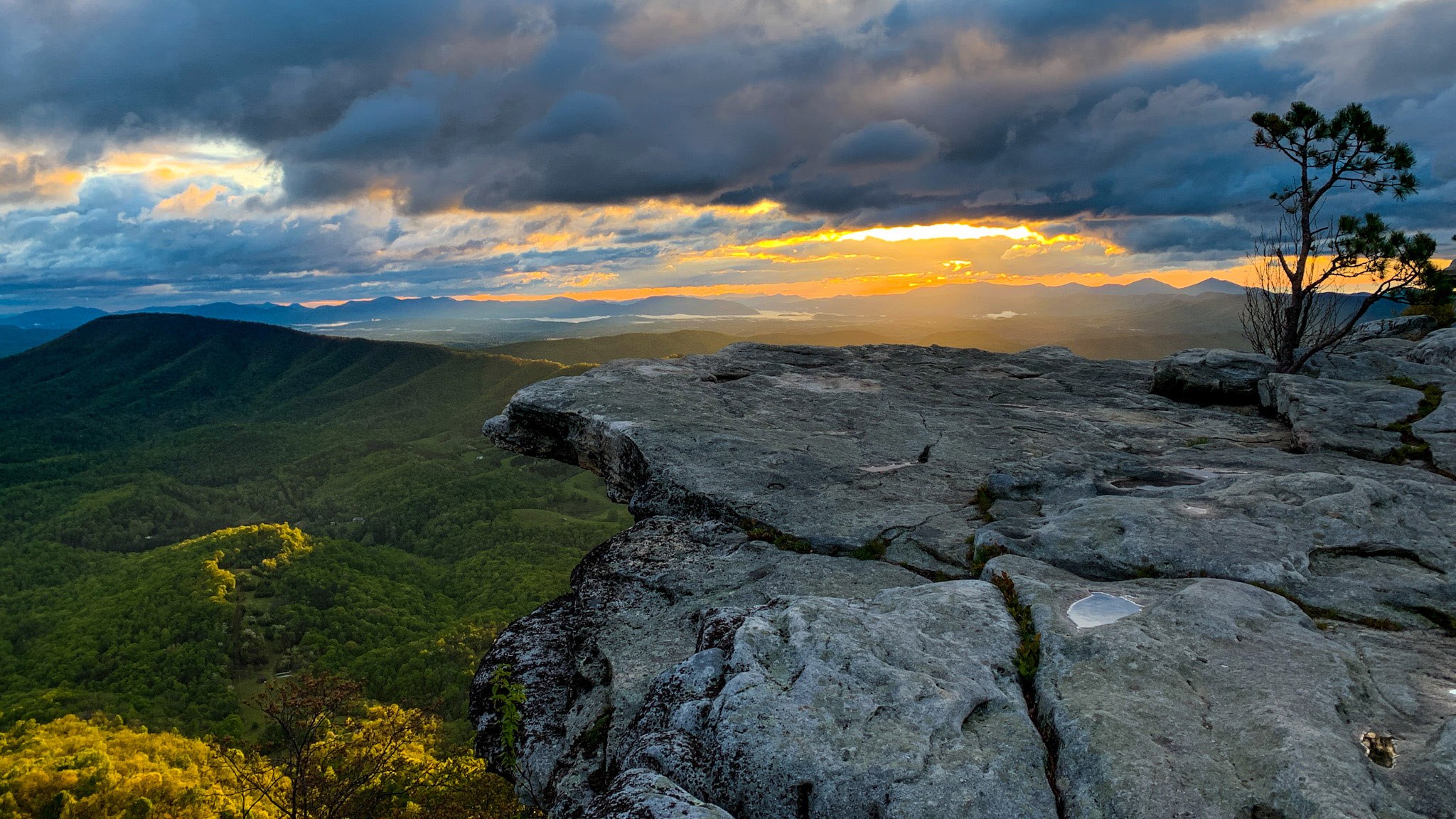
At an elevation of 3,197 feet, with a panoramic view of the Catawba Valley, McAfee Knob is one of the most photographed sites on the Appalachian Trail (A.T.). Yet it wasn’t even included in the original route planned out by trail mappers in in the early 1930s, according to documents recently discovered in the Roanoke Appalachian Trail Club’s archives. Instead, the trail was supposed to follow the crest of the Blue Ridge Mountains, passing about 15 miles east of the Knob.
Thankfully, members of the just-formed Roanoke Appalachian Trail Club (RATC) convinced master trail planner and chair of the Appalachian Trail Conference (now Conservancy) Myron Avery to reconsider the route, and today hiking to the Knob is considered an essential part of the AT experience, with more than 50,000 hikers a year tackling the moderately difficult ascent.
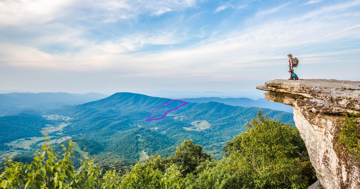
Today’s RATC is working closely with the Appalachian Trail Conservancy (ATC) to protect the site and its viewshed as part of a coalition of stakeholders that includes Visit VA’s Blue Ridge, Virginia Tech, the Virginia Department of Transportation (VDOT), Roanoke County, the Conservation Fund (TCF), and the Virginia Outdoors Foundation, which has provided $416,200 in grants from VOF’s Forest Core Fund to protect two parcels in Botetourt County, Hogan Hollow and the Rickman property. The two parcels total over 350 acres, containing part of the A.T. footpath and also forming part of the viewshed from the summit.
The grants helped cover the properties’ purchase price, surveying costs, legal and appraisal fees, title work, and environmental site assessments. It also helped ATC and TCF establish legal boundaries for the Hogan Hollow parcel, enabling the transfer of ownership to NPS. “There were conflicting boundary claims on one of the parcels, and all we had was a trail easement on the path,” says Andrew Downs, the senior director of the ATC’s southern region. “It was underprotected in our view.
“My favorite aspect of this whole process has been how all these different partners came together and started moving the needle towards a better-protected, more accessible, more responsibly used McAfee Knob,” he notes.
Work on a new, more accessible trailhead is underway. In the meantime, volunteers from the RATC continue their work for the trail, educating hikers about leave-no-trace principles and other important information about using the trail responsibly. These volunteers, known as the McAfee Knob Taskforce, also help to steward the trails by reporting problems. According to the Roanoke Outside Foundation website, 52 Volunteer Taskforce members logged 1,678 volunteer hours and spoke with over 19,000 visitors to the AT in 2019.
“The whole community has really rallied around this location, and it’s been wonderful to see,” Downs notes. “Everyone is stepping up with a message of preservation.”
Thank you, Andrew Downs, Diana C., and all the other great Roanoke and Botetourt area people who keep on saving and maintaining “our”Trail.
Be advised that Apex Clean Energy’s plans to build thirteen 655-foot wind turbines on a ridgeline on North Mountain in northern Botetourt County will significantly affect the viewshed from McAfee Knob. I discovered this in May 2020, alerted the local Roanoke office of the AT Conservancy on 19 May 2020 (VARO leader Andrew Downs), who said this organization is NOT OPPOSED to this wind turbine project. I followed up with more facts to AT Conservancy’s HQ but never received a reply. Due to the significance of this viewshed, I strongly urge this issue be revisited as the wind turbines have not yet been permitted for construction by Botetourt County.
Search the FAA’s Obstruction Evaluation Website,
https://oeaaa.faa.gov/oeaaa/external/searchAction.jsp?action=showSearchArchivesForm
Enter Signature Control Number: 508837026-519730393 and the thirteen planned towers, with heights and GPS coordinates, are provided. Mapping these points one can confirm my calculations that from McAfee Knob, North Mountain will be visible just to the right of Tinker Mountain (peak elevation 2917 feet), with the top of the wind turbine blades ranging from 3509 to 3919 feet, at a distance 27 miles, bearing 38.4°. ALL the turbines and blades would be visible from McAfee Knob, at TOP DEAD CENTER OF THE VIEW. Due to the orientation of all towers with respect to a viewer on McAfee Knob, the project’s visibility will be prominent in spite of the distance.
I urge all who care about the AT viewshed to publicly oppose and object to this project so it never gets built in this ill-sited location.
I applaud the efforts of RATC and ATC to preserve the “iconic view from McAfee Knob, one of the AT’s most photographed views.” Unfortunately, however, there is a project called Rocky Forge Wind, that if built could destroy that iconic view and make the recent purchase of the Rickman and Hogan Hollow properties moot. As detailed in the comment by Eric Claunch, if the 13 turbines that are currently proposed by Apex Clean Energy are built, they will clearly be visible from McAfee Knob. In addition to the glaring white towers and blades, the FAA requires that they be lighted with bright red blinking lights that are visible for miles and miles to prevent planes from colliding with them.
As with most industrial-sized projects of any kind, there are pros and cons that must be considered. Apex naturally claims that the electricity produced by the turbines will help reduce greenhouse gasses and help mitigate climate change. Unfortunately, the claims that Apex makes cannot be independently verified since they refuse to release the wind speed data collected at the project site, claiming that it is “proprietary.” But even if you assume that Apex’s claims of electricity for “up to 21,000 homes” are true, that number is for only 125 days in the year, and constitutes only 0.082% of the annual electricity usage in Virginia. If a goal of 30% renewable energy were to be met, that would mean 368 projects like Rocky Forge would have to be built. Every mountain ridge in Virginia would be destroyed.
While the DEQ has approved the plans by Apex for Rocky Forge, that approval has been challenged by a group of local citizens. Like the MVP and ACP projects, approval by regulatory agencies does not mean that the project is without serious adverse environmental impacts. For example, Apex has refused to apply to the USFWS for “incidental take” permits for the eastern golden eagles that have been documented at the Rocky Forge site within the Appalachian Migratory Bird Flyway.
I strongly urge RATC and ATC to research the effects that Rocky Forge would have on the views from McAfee Knob and reconsider their support for the Rocky Forge project. Because the facts show that building Rocky Forge will destroy the unique scenic value of McAfee Knob, I strongly urge all organizations and individuals who cherish this AT overlook to quickly engage in this discussion, and make your voices heard before all permits are acquired and construction begins. For more information, please email contact@VirginiansForResponsibleEnergy.org
Jeff Scott
I totally agree to preserve the natural beauty of the mountains of Virginia. So let’s not destroy a lovely view shed for a short term “solution” to “solve” climate change via the huge wind turbines proposed in the Rocky Forge project which will require razing the top of North Mountain–in the view shed of McAfee Knob–and building large cement foundations which will be permanent scars. The turbine lifespans are perhaps 10 years give or take, and don’t even provide a significant increase in the power grid.
It it important that VOF always acknowledge in these web site articles as well as all other news media that the origin of money from the “Forest Core Fund” came directly from the destruction in Virginia of over 100 miles of privately owned forests, farmland, streams and mountaintop ridges along the “right-of-way” of the Mountain Valley Pipeline. It is notable that the majority of the money from the Forest Core Fund has been given to projects, like the ones referenced in this article (in Botetourt County), that are nowhere near the MVP while communities such as Bent Mountain that are currently being destroyed by the aggressive construction practices of the development of this unneeded project have received absolutely nothing. VOF should NEVER publish an article about the Forest Core Fund without explaining where the money comes from. And, it should also be pointed out that the private land was taken through eminent domain. To omit this important information goes against the “transparency” claim that the VOF and this website makes.
Comments are closed.